
The long way down California’s coast
A week on the Pacific Coast Highway, from Big Sur's cliffs to Santa Barbara's palms, proves the best escapes can be the ones close to home.
“Big Sur is the California that men dreamed of years ago.” —Henry Miller
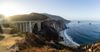
As I approached Bixby Bridge along the Pacific Coast Highway, I understood the line—and why Miller, who found his way to this coast in 1944, never really left. He settled down the road on Partington Ridge, in a cabin he called “his first real home in America,” and spent nearly two decades writing about Big Sur as a kind of earthly paradise.
I’d set out from Los Angeles earlier that morning, and as the hours rolled on, the road grew narrower and windier, until I was navigating the tight turns of the jagged California coast. It was early spring, and Highway 1 through Big Sur had just reopened in January, when crews finished clearing a string of landslides and rebuilding a collapsed stretch of roadway to reconnect the full 90-mile route.
For the first time in three years, I was able to drive the entirety of the north-to-south route, thrilled that the coastal byway that holds such significance to the West Coast psyche hadn’t been permanently damaged.
From the backseat to behind the wheel
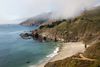
I’d visited California often on childhood road trips with my parents, and this highway usually heralded the midway point of our cross-country adventure. We would spend weeks in the Golden State before returning east, heading home across the mountains and the plains back to New Jersey. I remember gazing out the backseat window at the vast expanse of the Pacific Ocean, thrilled by the rollercoaster feeling of it all—the sharp turns, the vertical drops.
As an adult driving this stretch, the thrills only magnified. The Northern California dreamscape felt utterly unchanged, except now I was the one behind the wheel, with my boyfriend and dog in tow instead of children. It took us five-and-a-half hours to drive from Los Angeles, and though we got there fast, we spent the next few days going slow, aiming to stretch our getaway into one of those relaxed, breezy road trips of yesteryear.
In Big Sur, we basecamped at Alila Ventana Big Sur, set in the hills south of Bixby Bridge. Weaving through the dense forests and log cabins as we approached the 160-acre property felt like arriving at summer camp—albeit one that’s ultra-chic and more reminiscent of The White Lotus than The Parent Trap. We dined alfresco at The Sur House, where cliffside views of the signature marine layer transitioned to sparkling stars overhead as night fell, the lack of light pollution turning the sky into a planetarium. We spent our days whale-watching (a mandatory activity in Big Sur, where gray whales migrate in winter and humpbacks arrive in summer through fall), lounging poolside beneath the redwoods, and enjoying sundowners in the Adirondack chairs overlooking the cliffs below.
On the final morning of our stay in Big Sur, we paid an obligatory visit to Nepenthe, the clifftop restaurant that has drawn artists, writers, and bohemian wanderers since it opened in 1949. It began hosting poetry events and dancing under the sky, and the freethinkers followed—Henry Miller and Jack Kerouac among the writers, and cultural figures like Joan Baez and Elizabeth Taylor. It gripped Kerouac, who wrote about it in his novel Big Sur, detailing this region that seduced and unraveled him in equal measure.
On our drive, the moody, misty, and rainy Northern California weather enhanced the drive. Fog had rolled in overnight, swallowing the cliffs and the coastline 800 feet below—Big Sur at its cinematic, and somehow better for it. The overcast held as we pointed the car south, past roadside pull-offs with postcard ocean views and gas stations tucked against the forest. Then, in true Pacific Coast fashion, the clouds broke, and the sun came back later in the day.
The slow road south
Check the road first
Big Sur’s stretch reopened in full in January 2026, after three years of landslides and a roadway collapse closed sections of the route, finally reconnecting the drive between Carmel and Cambria. It’s whole again, but this is a coastline that moves — winter storms can still trigger rockslides and temporary one-way controls with little warning, so check an online map and road status updates before you set out, and again the morning you drive.
Go in shoulder season
Spring and fall give you the clearest, most reliable coastline, with wildflowers in spring and warm, settled light in autumn. Summer looks like prime time on paper, but the marine layer often rolls in and hides the cliffs until midday. It’s atmospheric, but not the postcard you drove all this way for. Whenever you go, save the most scenic stretches for late afternoon, when the light turns golden and the day-trippers thin out.
Don't rush it
You can drive the open route in a single day, but the stretch rewards at least two or three. The turnouts, the trailheads, and the cliffside lunches are the whole point, not detours from it. Build in time to pull over on a whim and plan your driving for daylight: the road is narrow, winding, and unlit, and the views are wasted in the dark anyway.
Fuel up, and book ahead
Gas and lodging both thin out the moment you leave the bigger towns, so plan around the gaps. Fill up in hubs like Monterey, San Luis Obispo, or Santa Barbara rather than counting on what’s between them. The Big Sur stretch, in particular, is sparse and notoriously pricey, so top off in Carmel if you’re driving south, or Cambria if you’re heading north. Rooms along the coast are just as limited, from Big Sur’s handful of inns and lodges to the boutique hotels in towns, and they fill quickly through most of the year. Reserve as far in advance as you can.
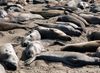
We took the southbound stretch out of Big Sur slowly, pulling over for every landmark worth it. First was the Piedras Blancas elephant seal rookery, a few miles north of Hearst Castle, where a free boardwalk runs parallel to the bluff. Here, hundreds of northern elephant seals stay on the sand year-round, close enough to the boardwalk that it’s easy to register their size. Bulls can run up to 4,500 pounds, with the biggest seals present in December and January.
A few miles on, we stopped in Morro Bay for lunch at Tognazzini’s Dockside Restaurant, a no-frills local institution, eating shrimp and oysters on the patio with Morro Rock filling the view. A suntanned guitarist sang yacht rock favorites as vacationers and locals clustered at nearby picnic tables. Not a bad life, I decided—and not for the first or last time of the trip.
From there, the route continues south through San Luis Obispo (affectionately called SLO), the Central Coast city that National Geographic author Dan Buettner once named the happiest place in America. It’s not hard to see why: the town sits in a bowl of rolling hills ringed by the Nine Sisters, a chain of ancient volcanic peaks running down to the sea. A little farther south, the Oceano Dunes stretch for 18 miles behind the white sand of Pismo Beach—the largest coastal dunes remaining south of San Francisco, and the only place in California where you can still drive right onto the beach.
SLO is still a bit of a sleeper. It’s quirky and low-key, anchored by the Madonna Inn, the gloriously pink roadside landmark on the edge of town. We stopped in for pink cocktails and a slice of its famous pink champagne cake, then chased the region’s other calling card: wine. The SLO Coast is fast becoming known for its excellent varieties, especially the crisp Albariño (perfect for a sunny California day). From there, it’s under two hours to the last, and one of the most iconic, stops on the route: the Hotel Californian in Santa Barbara.
A softer kind of coast
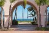
Santa Barbara is just as alluring as Big Sur and SLO, but in an entirely different way. It’s less rugged and remote, and more polished and warmer–but still unmistakably coastal. We stayed in the Funk Zone, a few square blocks of old warehouses between the railroad tracks and the beach. The area was a gritty industrial waterfront until the 1990s (the smell of the processing plants earning its ‘funky’ nickname), but has since become a trendy and eclectic haven for artists who moved into the vacant warehouses. Today the warehouses hold tasting rooms, galleries, and surf shops, as well as our hotel. The Spanish-Moorish Hotel Californian, with its tiled archways, palm-shaded courtyards, and black-and-white portraits of Old Hollywood on the walls, is as distinctive as it gets.
The next morning, we made the final drive home, and I felt as though I’d rediscovered the beauty, energy, and otherworldly allure of the coastline I remember from childhood road trips. I also realized I’d seen only a small part of it. Highway 1 runs 656 miles in all, from Leggett in Mendocino County down to Dana Point in Orange County. It’s a route that demands at least a week to give its distinct outdoor and cultural draws the time they deserve. For now, half the map is still waiting—the redwoods north of Carmel, the surf towns south of LA. I’ll be back for the rest.
Places to stay
Santa Barbara

Go further with the Expedia app
