![Take Hwy 89 through the Dixie National Forest. Hot in summer. Beautiful area to explore.
Dixie National Forest is a United States National Forest in Utah with headquarters in Cedar City. It occupies almost two million acres (8,000 km²) and stretches for about 170 miles (270 km) across southern Utah. The largest national forest in Utah, it straddles the divide between the Great Basin and the Colorado River. In descending order of forestland area it is located in parts of Garfield, Washington, Iron, Kane, Wayne, and Piute counties. The majority (over 55%) of forest acreage lies in Garfield County. There are local ranger district offices in Cedar City, Escalante, Panguitch, St. George, and Teasdale.[3]
Elevations vary from 2,800 feet (850 m) above sea level near St. George, Utah to 11,322 feet (3,451 m) at Blue Bell Knoll on Boulder Mountain. The southern rim of the Great Basin, near the Colorado River, provides spectacular scenery. Colorado River canyons are made up of multi-colored cliffs and steep-walled gorges.
The Forest is divided into four geographic areas. High altitude forests in gently rolling hills characterize the Markagunt, Paunsaugunt, and Aquarius Plateaus. Boulder Mountain, one of the largest high-elevation plateaus in the United States, is dotted with hundreds of small lakes 10,000 to 11,000 feet (3,000 to 3,400 m) above sea level. The forest includes the Pine Valley Mountains north of St. George
The Forest has many climatic extremes. Precipitation ranges from 10 inches (250 mm) in the lower elevations to more than 40 inches (1,000 mm) per year near Brian Head Peak 11,307 feet (3,446 m). At the higher elevations, most of the annual precipitation falls as snow. Thunderstorms are common during July and August and produce heavy rains. In some areas, August is the wettest month of the year.
Temperature extremes can be impressive, with summer temperatures exceeding 100 degrees Fahrenheit (38 degrees Celsius) near St. George and winter lows exceeding -30 degrees Fahrenheit (-34 degrees Celsius) on the plateau tops.
The vegetation of the Forest grades from sparse, desert-type plants at the lower elevations to stand of low-growing pinyon pine and juniper dominating the mid-elevations. At the higher elevations, aspen and conifers such as pine, spruce, and fir predominate.
The Dixie Forest Reserve was established on September 25, 1905 by the General Land Office. The name was derived from the local description of the warm southern part of Utah as "Dixie".[4] In 1906 the U.S. Forest Service assumed responsibility for the lands, and on March 4, 1907 it became a National Forest. The western part of Sevier National Forest was added on July 1, 1922, and all of Powell National Forest on October 1, 1944.[5] #RoadTrip](https://images.trvl-media.com/place/553248623139890761/0fda4c56-7838-41e8-8b93-58002efa6942.jpg?impolicy=fcrop&w=1200&h=500&q=medium)
拍摄者: Eric & Kristy's Adventures
搜索奥尔顿的农业旅游旅馆
查看这些日期的价格
奥尔顿农业旅游旅馆推荐
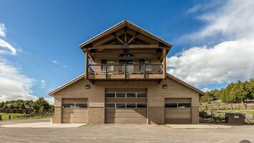
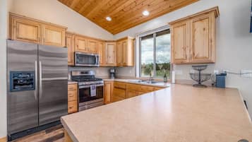
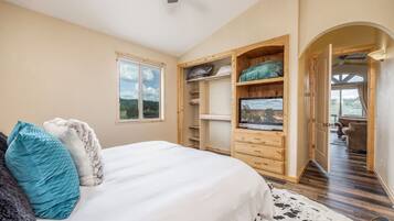
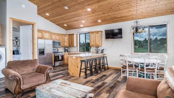
The Wildflower Hitchin' Barn-Near Zion and Bryce
Alton
每晚 $277
新价格 $308
11 月 30 日 - 12 月 1 日
总价含税费


Mini farmhouse style container Homes #1
Orderville
9.0 分,总分 10,好极了,(11)
“Very cute and comfortable. ”

Adam
每晚 $165
新价格 $186
11 月 30 日 - 12 月 1 日
总价含税费


The Barn Silo at Goose Lake Lane, East Zion National Park & Bryce Canyon National Park
Glendale
10.0 分,总分 10,绝佳,(20)
“We stayed 3 nights in mid-September. The barn silo is so cozy and comfy, and well appointed with everything you need. A grill, chairs outside to relax as well as comfy seating inside, comfy bed an nice linens. This was our home base for visits to Zion park- great location and a great place to relax after a long day of hiking!”
Gina E.
每晚 $312
新价格 $339
11 月 30 日 - 12 月 1 日
总价含税费
基于过去 24 小时内找到的、2 位成人 1 晚住宿的每晚最低价格。价格和供应情况可能会有所变动。可能需遵守其他条款。

奥尔顿热门酒店点评

布赖斯峡谷松树
10/10 优秀

89 & Nine 汽车旅馆
10/10 优秀
查看更多有关奥尔顿的信息
奥尔顿农业旅游旅馆信息
住客点评数 | 6 |
|---|---|
住宿 | 670 |
最低价 | $186 |
最高价 | $339 |
Expedia 带您探索世界
- 锡安国家公园附近的酒店
- 帕拉戈纳的酒店
- 帕罗宛的度假村
- 锡安峡谷游客中心附近的酒店
- 利兹的公寓
- 锡安国家公园南入口附近的酒店
- 斯普林代尔的酒店
- 斯普林代尔的农场
- 斯普林代尔的别墅
- 锡安国�家公园东入口附近的酒店
- 苹果谷的民宿
- 躲猫猫峡谷附近的酒店
- 卡纳巴的民宿
- 卡纳巴的休旅车露营区
- 卡纳巴的酒店
- 卡纳巴的日式旅馆
- 布莱斯峡谷的民宿
- 布莱斯峡谷的木舍
- 布莱斯峡谷的休旅车露营区
- 布莱斯峡谷的城堡
- 布莱斯峡谷的木屋
- 布莱斯峡谷的公寓式度假村
- 布莱斯峡谷的村舍
- 位于布莱斯峡谷的豪华酒店
- 位于布莱斯峡谷的Wyndham Hotels
- 布莱斯峡谷的酒店
- 布莱斯峡谷的公寓
- 布莱斯峡谷的度假屋
- 布莱斯峡谷的Pousadas
- 布莱斯峡谷的度假村
- 卡纳布附近的酒店
- 华盛顿的民宿
- 华盛顿的度假村
- 圣乔治的宫殿
- 卡纳拉维尔的私人度假屋
- 特罗皮克的酒店
- 布莱斯峡谷国家公园游客中心附近的酒店
- 格伦代尔的公寓酒店
- 位于格伦代尔的经济型酒店
- 托凯维尔的休旅车露营区
- 位于锡达城的探险运动酒店
- 位于锡达城的经济型酒店
- 锡达城的酒店
- 拉沃肯的公寓
- 拉沃肯的民宿
- 拉沃肯的私人度假屋
- 布莱斯峡谷国家公园附近的酒店
- 芒特卡梅尔的民宿
- 芒特卡梅尔的度假村
- 布莱恩海德的酒店
- 从巴里亚起飞的航班
- 从弗拉格斯塔夫飞往卡纳巴的航班
- 从卡尔斯巴德飞往卡纳巴的航班
- 飞往布莱斯峡谷的航班
- 从布莱斯峡谷起飞的航班
- 从卡纳布起飞的航班
- 从休斯敦 (IAH) 飞往卡纳布 (KNB) 的航班
- 从纽约 (JFK) 飞往卡纳布 (KNB) 的航班
- 从洛杉矶 (LAX) 飞往卡纳布 (KNB) 的航班
- 从奥克兰,加利福尼亚 (OAK) 飞往卡纳布 (KNB) 的航班
- 从匹兹堡 (PIT) 飞往卡纳布 (KNB) 的航班
- 从仙台 (SDJ) 飞往卡纳布 (KNB) 的航班
- 从锡达城 (CDC) 飞往布赖斯坎宁 (BCE) 的航班
- 从洛杉矶 (LAX) 飞往布赖斯坎宁 (BCE) 的航班
- 从芝加哥 (ORD) 飞往布赖斯坎宁 (BCE) 的航班
- 从波拉卡 (PXL) 飞往布赖斯坎宁 (BCE) 的航班
- 从圣迭戈 (SAN) 飞往布赖斯坎宁 (BCE) 的航班
- 从旧金山 (SFO) 飞往布赖斯坎宁 (BCE) 的航班
- 从盐湖城 (SLC) 飞往布赖斯坎宁 (BCE) 的航班
- 从橘郡 (SNA) 飞往布赖斯坎宁 (BCE) 的航班